The ultimate long weekend in Victoria's high country: a five-day guide to the Alpine Road, the Black Spur and everything in between.
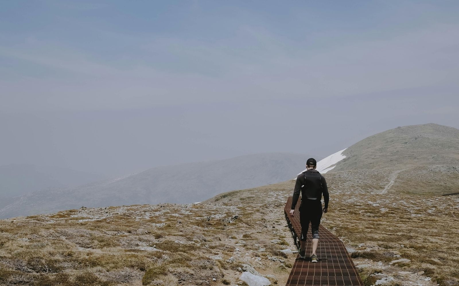
There is a stretch of highway in Victoria’s northeast that climbs 1,300 vertical metres through hairpin bends to a summit at 1,840 metres above sea level. It is the highest year-round sealed road in Australia, and at Danny’s Lookout — roughly 1,700 metres up, with 360-degree views across Mount Feathertop, Mount Buffalo and the Bogong High Plains — it will rearrange your priorities for a while.
That road is the centrepiece of this trip, but it’s not the whole story. Over five days across Easter, you can string together the King Valley, Beechworth, the alpine ascent, the twisting Eildon-Jamieson Road and the cathedral-like Mountain Ash forests of the Black Spur into one continuous loop from Melbourne and back. Every road is sealed. Every campsite is free. And if you’re travelling with a dog, almost all of it works — with a few critical caveats.
Here’s how to do it, day by day.
Day one: Melbourne to the King Valley
Edi Cutting, King River
View this post on Instagram
The first camp sets the tone. Edi Cutting sits directly off the Wangaratta-Whitfield Road in the King Valley, a few hundred metres of shaded campsites stretched along the King River under towering gums. It’s free, first-come-first-served, and dogs are welcome on lead. There are two drop toilets (one at each end), fire pits, and phone coverage. No drinking water.
The river itself is right there for wading — bring shoes, because the bed is rocky — and a morning coffee by the fire with mist lifting off the water is worth the drive alone.
The access is fully sealed and there are no 2WD issues at all.
Where to eat
The Mountain View Hotel in Whitfield is 20 minutes south and worth the detour. Owned by Pizzini Wines, it has a beer garden under 90-year-old trees with views toward Mount Buffalo. Dogs are welcome in the garden. Book ahead, especially over Easter.
If Edi Cutting is full
Easter camping in the King Valley fills fast. Three backup options, all free, all dog-friendly, all 2WD accessible:
Pioneer Bridges Rest Area, Markwood — 25 km from Edi Cutting, about 20 minutes. On the banks of the Ovens River at 285 Markwood-Everton Road. Flat, shady sites under large deciduous trees with a sandy bank down to the river. Managed by DEECA, upgraded in 2023. Toilets, picnic tables, fire pit. Swimming, fishing, kayaking. Adjoins a sealed road. Gets very busy over long weekends, so arrive early.
Stringybark Creek Camping Area, Toombullup State Forest — 40 km south, about 40 minutes via the C521 through Whitfield and Tolmie. Large sites in natural bushland. Pit toilets, fireplaces, picnic tables. The Kelly Gang ambush site from 1878 is a short interpretive walk away. The road is mostly gravel but still a good 2WD track. Usually less crowded than Edi Cutting.
River Road Reserve, Tarrawingee — 40 km north, about 30 minutes via Wangaratta. Small bush camping along the Ovens River, shaded by Manna Gum and wattle. No facilities at all — self-contained camping only. Good if you arrive late and just need somewhere close to Wangaratta.
Day two: Powers Lookout, Beechworth and Yackandandah
View this post on Instagram
Morning: Powers Lookout
About 30 minutes south of Edi Cutting near Whitfield. A 3 km unsealed gravel road leads to a carpark with two lookout points offering sweeping 240-degree panoramic views across the King Valley and surrounding ranges. One lookout is wheelchair-accessible at the carpark; the other involves a short walk through caves and rock formations with ladders and stairs. Picnic tables, shelter, toilets and BBQs are all on site. The access road is 2WD in dry conditions.
Powers Lookout is a scenic reserve managed by Parks Victoria, not state forest. Dog policy here falls into a grey area — scenic reserves are a different category from national parks, and rules vary by individual reserve. Call Parks Victoria on 13 1963 before visiting to confirm.
Late morning: Beechworth
About an hour from Edi Cutting, heading north through the King Valley to Wangaratta and then east on the C315. The approach into town through the Beechworth Gorge is striking — granite outcrops and eucalypt forest frame the road.
Beechworth is one of Victoria’s best-preserved gold rush towns, and there’s plenty to do with a dog in tow.
Historic Precinct walk — 1850s granite buildings including the Courthouse, Sub-Treasury and Stone Lock Up (where Ned Kelly was held). Dogs can enter the Lock Up. Self-guided walking tour brochure from the Visitor Centre for $1.
Beechworth Historic Park and Gorge — Mining sites in beautiful bushland. Dogs allowed on-leash. Granite gorge landscape, Powder Magazine and One Tree Hill. Check at the Visitor Centre whether Spring Creek Bridge is open.
Lake Sambell circuit — 2 km loop, about 40 minutes. Dogs on-leash. A former open-cut sluice turned recreation reserve. The adjacent Chinese Gardens and Bush Botanic Gardens are a peaceful short wander.
Lake Sambell to Lake Kerferd walk — 5 km each way through eucalypt forest. Watch for koalas, wombats and wallabies. Stick to the track — there are disused mining shafts in the area.
Murray to Mountains Rail Trail — Starts near Lake Sambell. Dogs on-leash. Flat, sealed, old railway line.
Off-leash — Baarmutha Park Recreation Reserve, on the northeastern side of town.
Skip Mount Pilot and Woolshed Falls — both are in Chiltern-Mt Pilot National Park, where dogs are not permitted.
Beechworth Bakery — The queue moves fast. Get the beesting.
Afternoon: Yackandandah
25 minutes south of Beechworth. Smaller, arguably more charming, with a less polished and more local feel than its northern neighbour. Excellent cafes, a community-owned pub and craft shops line the main street.
Camp: Yackandandah Creek, Stanley State Forest
From Yackandandah, head south along Bells Flat Road into the Stanley State Forest. There are 10 campgrounds along Yackandandah Creek, all upgraded in 2023. Campground 7 is a good pick. Free, first-come, dog-friendly. Drop toilets, wood-fired BBQs, fire pits. No water. Limited phone reception. Gravel road, 2WD in dry conditions. Surrounded by enormous old-growth gums with creek access. Popular with dirt bikers and mountain bikers during the day. Over Easter, arrive early afternoon to secure a spot.
Where to eat and drink
Beechworth — Tanswells Commercial Hotel on Ford Street is a grand 19th-century pub. For craft beer, Bridge Road Brewers operates out of a 150-year-old coach house and does excellent pizza.
Yackandandah — The Yackandandah Hotel (the Bottom Pub) has a sunny beer garden and excellent parmas. The Star Hotel up the road does house-smoked BBQ meats.
Day three: Myrtleford, Bright and the Ovens Valley
View this post on Instagram
Morning: Reform Hill, Myrtleford
From Yackandandah, take the Myrtleford-Yackandandah Road through Mudgegonga. About 45 minutes of rolling farmland and forest.
Reform Hill is the best confirmed dog-friendly lookout on the entire trip. Drive almost to the 545-metre summit via Scenic Road, leaving just a 50-metre stroll to the lookout platform. It sits in Reform Hill State Forest, so dogs are welcome on-leash. Panoramic views take in Myrtleford township, the Ovens Valley, Mount Buffalo and the Victorian Alps. There’s a picnic table, a lookout tower and a mosaic trail featuring 13 artworks depicting threatened species. Allow 30 to 45 minutes.
Optional: Lake Buffalo
A 45-minute return drive south from Myrtleford along Buffalo River Road. The lake is managed by Goulburn-Murray Water (not a national park), so dogs are welcome. Picnic tables, BBQs, toilets. The drive passes cattle grazing country, hops farms and apple orchards. Excellent autumn scenery.
Midday: Bright
30 minutes from Myrtleford along the Great Alpine Road, which follows the Ovens Valley through tobacco kilns, hop gardens and orchards with Mount Buffalo rising behind.
Walk along the Ovens River — the Cherry Walk and Canyon Walk are both dog-friendly. Early April is about two weeks ahead of peak autumn colour, which typically peaks mid-April to early May (timed with the Bright Autumn Festival). Expect early transition with patches of yellow and spotty orange-red. Coronation Avenue around Pioneer Park and Delaney Avenue have the best displays.
Bright Brewery — Dog-friendly outdoor dining area and deck overlooking the Ovens River. Craft beers, solid pub meals.
Sixpence Coffee at 15 Wills Street — Small-batch roastery with excellent coffee, bread and pastries.
Gum Tree Pies — For gourmet pies.
Optional: Buckland Valley detour
At the Porepunkah roundabout (opposite the Mount Buffalo turnoff), turn left onto Buckland Valley Road. Vineyards and apple orchards with Mount Buffalo’s granite cliffs as backdrop. Drive to the end of the sealed section and turn back. Dog-friendly in the state forest beyond the sealed section. About 30 minutes return.
Mount Buffalo National Park — In-and-out road with no through-route. The transit exception does not apply. Skip it with a dog.
Camp: Smoko Campground (Smoko Streamside Reserve)
Continue south from Bright through Smoko to Harrietville (20 minutes). The historic Tronoh Dredge Hole on the edge of Harrietville is worth a look. Then head 8 km back north from Harrietville to Smoko Campground, just off the Great Alpine Road. This is a streamside reserve managed by Parks Victoria (not state forest). Free, dog-friendly on lead, first-come-first-served. One pit toilet, fire pits, picnic tables. No water. Access is via approximately 1 km of gravel on Miley Lane, 2WD accessible in dry conditions. Watch for potholes after rain. Check fire restrictions before lighting any campfire.
Backup camp — Ah Youngs Campground, Buckland Valley State Forest, approximately 18.7 km southwest of Porepunkah. Managed by DEECA. Free, dog-friendly. One drop toilet, fire pits. The road to the area is 2WD in all weather, but access to the campsite itself is dry-weather only for 2WD vehicles.
Day four: the Great Alpine Road and Tawonga Gap
View this post on Instagram
This is the big one. Approximately 200 km of driving including the Hotham out-and-back.
Morning: Tawonga Gap Road
From Bright, head over the range toward Mount Beauty. The Tawonga Gap Road is 30 km each way, about 35 minutes in each direction. Fully sealed, 2WD, narrow with tight bends and blind corners. The route passes through nut plantations before entering forested areas. Allow about an hour including lookout stops.
Tawonga Gap Lookout — A viewing platform with expansive views across the Kiewa Valley to Mount Emu and Mount Bogong (Victoria’s highest peak at 1,986 metres). Within the Tawonga Gap Scenic Reserve, managed by Parks Victoria.
Sullivans Lookout — 1.4 km further toward Mount Beauty. Clear views of Bogong and the Kiewa River floodplain. Roadside pull-in, no hiking required. Also within the Tawonga Gap Scenic Reserve.
Dog policy at both lookouts is genuinely ambiguous in official sources. Scenic reserves are a different category from national parks, and the rules vary by individual reserve. Call Parks Victoria on 13 1963 before visiting to confirm. Return to Bright via the same road.
Afternoon: the Great Alpine Road to Mount Hotham
From Bright, head south through Harrietville. From Harrietville (elevation approximately 510 metres), the Great Alpine Road (B500) climbs 1,300 vertical metres in 30 km through hairpin bends to the summit at 1,840 metres — the highest year-round sealed road in Australia. It’s a standard sealed road with crash barriers, fine for any 2WD vehicle. No resort entry fees apply outside snow season (which begins on King’s Birthday weekend in June). Allow one to one-and-a-half hours for the drive up.
Lookouts on the ascent
Renes Lookout — At the top of CRB Hill, roughly 24.5 km from Harrietville. Ridge views across the ranges.
Danny’s Lookout — The premier viewpoint on the entire road and the standout view of the trip. Approximately 4 km west of Mount Hotham village at around 1,700 metres elevation. Panoramic 360-degree views of Mount Feathertop, Mount Buffalo and the Bogong High Plains. This is within the Alpine National Park — dogs must remain in the car, and technically you should keep moving. A brief stop with a dog in the car carries minimal enforcement risk, but the legal position is as described above.
The final 10 km beyond the summit is a ridgeline section with numerous unnamed pullovers offering sweeping alpine panoramas.
Dinner Plain
10 to 12 km beyond the summit. A purpose-built alpine village among snow gums with year-round cafes. Mountain Kitchen is listed at 1 Big Muster Drive but its operating status can be inconsistent outside peak season — contact the Alpine Visitor Information Centre in Bright on (03) 5755 0584 to check before relying on it.
Total out-and-back from Harrietville: approximately 84 km, about three hours with stops.
Camp: Smoko Campground again
Return to Smoko for a second night if you camped here yesterday, or make it your first night if you structured the trip differently.
Day five: the Eildon-Jamieson Road and the Black Spur
View this post on Instagram
Approximately 430 km of driving. This is a big scenic day — leave early, aim for 7am.
Morning: drive to Jamieson
Smoko to Bright, then the Great Alpine Road north to Wangaratta, south on the Hume (M31) to Benalla, the Midland Highway (B300) to Mansfield, then south to Jamieson via the Mansfield-Woods Point Road (C511, 37 km, fully sealed). All sealed, all 2WD. Allow three to three-and-a-half hours.
Do not continue south of Kevington toward Woods Point. The road becomes unsealed beyond Kevington and the gravel surface is slippery in wet weather. Leave this one for the 4WD crowd.
Late morning: the Eildon-Jamieson Road
From Jamieson, head west. 63 km of what is widely considered one of the most winding sealed roads in Victoria. Steep switchbacks, dense bush, occasional views of Lake Eildon and Big River State Forest. Fully sealed, 2WD accessible. Allow one to one-and-a-half hours.
Eildon-Jamieson Scenic Lookout — Roadside pullover about 6 to 7 km from the Jamieson end. Stunning Lake Eildon views. Outside Lake Eildon National Park, so dogs should be fine.
Eildon Spillway Lookout — In the township of Eildon, managed by Goulburn-Murray Water (not a national park). Views down the Goulburn River Valley. Sealed road, parking, toilets, covered seating with interpretive signage. Dogs permitted on lead.
Around midday: Marysville
About 40 minutes from Eildon. Head south to the Maroondah Highway via Alexandra and Taggerty. At Narbethong, turn left onto Marysville Road for the 9 km drive into town.
Marysville was devastated by the Black Saturday fires in 2009 and has been beautifully rebuilt. Good cafes and a bakery — a coffee stop is well earned at this point.
Steavenson Falls (84 metres, one of Victoria’s highest) is 4 km from the town centre. Dogs are not permitted on the 700-metre trail to the viewing platform — they can remain in the car park only.
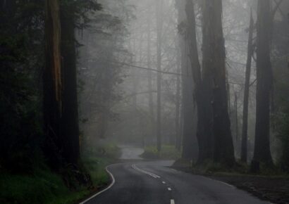
Early afternoon: the Black Spur
28 km of the Maroondah Highway (B360) between Narbethong and Healesville. Towering Mountain Ash — Eucalyptus regnans, the tallest flowering trees on earth, capable of exceeding 100 metres — line both sides while dense tree fern undergrowth creates something approaching a cathedral atmosphere. Fully sealed, 2WD, 80 km/h. Through Yarra Ranges National Park, so dogs stay in the car.
Dom Dom Saddle — The highest point at approximately 550 metres. Picnic tables are present but note that Parks Victoria lists this as within Yarra Ranges National Park, so dogs must stay in the car. Also note that the toilets at Dom Dom Saddle have been permanently closed.
Fernshaw Picnic Area — Approximately 10 km from Healesville. Heritage deciduous plantings including oaks, cork oak and American redwoods provide autumn colour. Toilets and gas BBQ. Within the national park, so dogs stay in the car.
Optional: Kinglake National Park detour
Between Healesville and Melbourne. Frank Thomson Reserve is the one area within Kinglake National Park where dogs are allowed on-leash, with views toward the Melbourne skyline on clear days.
Home
From Healesville, approximately one hour back to central Melbourne via the Maroondah Highway and Eastern Freeway. Allow up to one-and-a-half hours in peak traffic. With a coffee stop in Marysville and a leisurely Black Spur drive, expect to be home by mid-to-late afternoon.
Find out more here.